Looking Southwest to the Rio Grande from our front yard. Del Norte Peak (12,400′) in the background.
Gary and I have been dragging our sorry asses around the house for 2 days now packing for a trip we leave on tomorrow. We pack a little, take a nap, sit by the river, lay in the sun, go for a ride, visit with friends and basically drag our heals in any non-productive way we can find. We’re going to the Northwest for crying out loud…… a favorite summer destination for half the country. We’re going to see both our families and grandkids for Pete’s sake. So what’s not to like?
Leaving our little log cabin here on the banks of the Rio Grande, that’s what. And that’s not all….. because of the recent weeks of rain we’re leaving the San Luis Valley in a state of such lush beauty, the likes we’ve not seen in our 14 years here – the wildflowers will soon be absolutely insane. And there’s more – here on the Rio we live in a virtual wild life refuge with foxes, coyotes, deer, raccoon, owls, raptors, rabbits, water fowl of all kinds and birds and birds and birds with a morning cacophony of song and sound that wake with the sun. We’ll miss the basic, deeply rich simplicity of our cabin life and sleeping in our loft at the base of an open window with a breeze which puts us to sleep. We’ll miss seeing the garden we’ve recently planted come to life. We’ll miss resting in the shade of a huge canopy of age old cottonwood trees which just now are decked out in their in full, green leaf regalia. We’ll not see the collection of sunrises and sunsets ahead of us. The river will continue to rise, and fall, the waters here today making it to Mexico by the time we get home in 3 weeks. We’ll miss all the spirited families with whom we have the honor of living with here on the Colville ranch and village as well the many friends we’ve made here in the Del Norte area, some we’ve known now for 20 years. I’ll miss the women of my weekly knitting group – they are woven now close to my heart. I’ll miss my job and playing with the babies I’ve come to be so fond. And, you are left saying……there has to be something they don’t mind leaving?? Sure, that’s easy, it’s the mosquitoes soon to hatch, but honestly, that’s about it.
Sorry for my inactivity on the blog. After we returned from our Idaho trip last year I hit the ground running, doing work. I’ve been working all winter and our piggy bank isn’t looking quite so lean anymore. I hope to play the bulk of the summer so hopefully I’ll blog more.
I’ve been needing a solo trip, a trip, that would blow out the cobwebs, a trip that would push me- physically, mentally and emotionally, a trip where my wants and needs were the only ones I was concerned with. This one was successful on all counts.
The photos are from my phone. Sorry for the poor quality.
Something is up with our wordpress program. I have the text below the photos when I edit but it changes. Sorry.
It was approaching 6:00 on my third day in the canyon. I had covered 17 miles since I stated walking before 7:00 AM. The last couple of hours had consisted of pushing through tangles of Tamarisk and Willows and searching for ways around rock slides and boulder jumbles. Any sign of a trail had disappeared hours ago. Then I came up to it. The slide. The volunteer ranger at Kane Gulch told me about, said he didn’t know of anyone that had gotten past it. The wind was gusting to what seemed like around 30 mph which added to the tension. After considering my options I thought I should go up to it and just see how it felt. I strapped my poles to my pack and inched my way up to it. I was surprised that it wasn’t as loose as it appeared. The slide probably happened last year so the dirt/rock conglomerate was firmer than it looked. So, very gradually and slowly, I tried it a bit farther. I promised myself I would not move a hand or foot until I was confident the other three had a solid hold. In probably three minutes I was past it. Then I realized how the adrenaline had been flowing… I had a shot of whiskey. This is playing for keeps. The term ‘no safety net’ crossed my mind.
The slope has given away right at the pour off. No way around. I climbed across it towards the top of the photo.The pour off of the slide that had blocked the route around. There’s no frame of reference as to how big it is. It is big enough…
Some years back Patti , myself and two friends had been in the Gulch. We went in Todie Canyon and exited at Collins Canyon. I told myself then that I wanted to hike the length of Grand Gulch one day, it’s 51 miles from the the Kane Ranger Station to the San Juan River.
A mile or so from the ranger station in Kane Gulch. This is a well used route.
I worked out a route where I’d leave my truck at the top of Slickhorn Canyon, I’d ride my bike from there to Kane (around 14 miles), leave the bike there, and do a loop.
It’s great to be back in canyon country.
Officially the loop would be about 80 miles, not sure how they can measure miles in there. The BLM does virtually no trail maintenance, the upper canyons see enough use that there are cairns and well worn paths but down lower you may find footprints here and there but you shouldn’t assume they know where they’re going any better than you.
The upper canyons of Cedar Mesa are chock full of ruins. The lower canyons, not so much.It’s not often ruins are this low, usually they are higher up the slope.
Room with a view.
Small hands. Broken thumb???
This arch in the lower Gulch was really impressive. It is massive.
There is also lots and lots of sand, which makes for slow walking. And, all this changes every year as the flash floods rip every thing apart in the monsoon season. All this to say 20 miles is a very long day here.
One of many log jambs and rock slides to negotiate. This log jamb is 70-100′ above the canyon floor! The fury of flooding, just imagine!
After I’d gotten over the slide I had about a mile to the River. It took close to an hour.
The San Juan and camp for the night.
The next hurdle was beginning. There was only rumors that there actually was a route between the Gulch and Slickhorn. Was it still there? Could I find it? Was it navigable? Looking at the slope that evening made me feel a bit doubtful.
Sunrise. I’d been walking 1/2 hour here.Grand Gulch is at the upper left of the photo.
I did find my way through. In the beginning there were three huge rock slides, finding the route was hit or miss for the first couple of hours. Eventually the shelf grew wider and the trail was there more than not. I had a few minor slides but nothing major.
Some of the sites along the route.
I hope to learn the history of this trail, I’ll update the blog if I do. I suspect it was built originally to get cattle into the area. It would take a lot of work to get it and keep it in condition that a cow could travel. It’s 3.5 river miles between the two canyons. It took 5 hours.
Surprisingly the trail didn’t drop me into Slickhon at river level but about a mile upstream above one of several pour offs. I still had some slides and bushwacking in the lower portion but once I made to Slickhorn #6 (a side canyon) things improved dramatically, I started seeing footprints and even some cairns.
Slickhorn in the morning.Almost out.
There were still a few slides and a bit of bushwacking in the lower portion but once I made to Slickhorn #6 (a side canyon) things improved dramatically, I started seeing footprints and even some cairns. The last hours out were bittersweet. I was really sad my little adventure was coming to an end, but looking forward to being back with my sweetie.
I left Cedar Mesa feeling like I know it a little better, probably close to a dozen trips there… so far. It’s a special place. I left, too, feeling physically drained but my batteries are fully charged- it’s been a while.
Thanks to Patti for editing the photos, such as they are. I’ll try to do a gear post for the gear junkies soon.
The Idaho Hot Springs Mountain Bike Route, just North of Stanley, Idaho.
June 25 -July 17 2014
Granted. Adventure Cycling did a marvelous thing when they mapped out the Great Divide Mountain Bike Route in 1997. They brilliantly took 2745 miles and over 200,000 feet of elevation gain from Banff, Canada to Antelope Wells, Mexico and laid it out in a user friendly format complete with where to get ice cream, coffee and a good micro-brew beer. They almost spoon feed you the route leaving space for other more important things, exciting things, like being chased by grizzly bears. Thousands and thousands of people from around the world have enjoyed the GDMBR and we’ve had the pleasure of hosting hundreds of them at our home, here in Del Norte, over the years. It’s a decent trade – the inspiration we glean is our only pay. We’ve ridden the route as well and can attest to all the hoopla – it’s well worth the effort if you’ve ever considered it.
So, we were more than excited to hear that Adventure Cycling was rolling out the Idaho Hot Springs Mountain Bike Route in the spring of 2014. With maps ordered and an invitation in hand, plans were made to take it on. What’s not to like, right? 517 miles of off road touring with 50 hot springs!! And it’s a loop meaning no logistical complications with the exception of getting yourself to the put-in, right where you’ll end up a couple of weeks later. Sweet!
We had been invited to join our dear friends Shawna and Kent on this adventure along with 2 mystery friends we had yet to meet. Let it be known that Shawna and Kent are well seasoned sages at picking out and organizing adventures so for us it was a no brainier. We were in, hard. In mid June the six of us rolled out of the Springs Shores Marina parking lot, outside of Boise Idaho, onto the surface we love the most – dirt – and started peddling the IHSMBR
THE CAST OF CHARACTERS……..
Shawna Marie ….. she is an adventurer supreme.Kent …. he seeks all things fun and all things water.Jeny ….. she smiles even in her sleep.Tom….crazy spoke man. He’s seriously funny even in his sleep.Patti …. she turned 60 on this trip.Gary …. he waited, patiently, for us all.
Come to find out, our cast of characters was probably among the first dozen or so to attempt this route since the roll out of the new maps. No doubt there was a herd of hundreds to follow over the summer and fall. We were “loopers” dedicated to complete, come hell or high water…. the Idaho Hot Springs Mountain Bike Route.
AND WHERE DOES THE RECLAMATION PART COME IN??? Let us tell you….
To start out with, personal goals are good, right? They come to to sit quietly next to us at the start of any adventure, like sleeping tigers. Our goals give us a structure, something to organize and something to move around in. We often don’t know how well tuned our body, bike, spirit and equipment may be for any given adventure, but we generally find out in short order and make adjustments accordingly.
Throw recovering from cancer into the mix and we all step aside, humbly, earnestly, trumped. That was the wild card that Shawna was playing and there was no way of knowing what was in store for her. In March of 2012, Shawna had been diagnosed with breast cancer, putting up the good fight with surgeries, chemotherapy, radiation and chaos of the worst kind. On this first “post cancer” trip of this magnitude she was indeed taking herself out on a hell of a test drive .. a very, very big test drive. The significance of this trip held in it’s hands the potential reclamation of Shawna’s life. The guns were indeed loaded.
While Shawna’s tigers weren’t obvious to the naked eye…. Gary’s, well, not so much. This is what Gary rolled up to the starting line with….
Notice his right calf is super swollen. A routine stretching regime gone bad??
The massive swelling in Gary’s right, lower leg happened a couple of days before the trip as a result of going through some basic stretches. It pretty much stayed the same throughout the entire trip, but didn’t seem to slow him down much. Six months later, it was just barely back to normal.
OK, back to the loop and some logistics…. First of all it’s all doable, just pick a pace you can live in and it’s all good. Much like the rest of life, right? As mentioned before, it’s a loop, a big, sweet loop. With the simple purchase of an annual park pass we were able to park our vehicles at Spring Shores Marina which was terribly convenient as it was also the starting point. To make it even more convenient we were able to camp in the parking lot the night before we left….. sweet…. so it seems. But, believe me, there was much tado about nothing, confusion and a variety of communication mishaps with the seemingly in-the-dark marina folks indicating just how few people had attempted this prior to us. In the end, they consented to let us stay there, but by their resistance to the whole idea we’re thinking we may have been some of the first and the last to benefit, which is a shame as it’s the perfect starting point. Y’all can give it a go, it’d be worth a try. The park has probably dialed in their regulations around the whole thing by now. Regardless, parking at the marina allowed us an additional 15.5 beautiful, dirt miles (31 round trip) along the shores of the Arrowrock Reservoir to the actual start of the loop.
The route proved to be accurately mapped with the exception, possibly, of the 4 mysterious single track sections which we’ll get to later. The longest climb is either at the beginning of the ride or at the end depending on which direction one takes. We headed east, putting the 3,300 climb out of Idaho City at the very end of the trip.
The first two days of the actual loop were along a gravel road in excellent condition which ran along the Middle Fork of the Boise River. It was the perfect grade for warming up the legs complete with hot springs, sun and rain. 55 miles later we took our only diversion off the main route towards the start of the first single track section (Willow Creek option) continuing up a gentle grade to the mountain town of Atlanta. Starving, we ascended upon the only bar/restaurant in town and along with some marginal food we got a heap big serving of local comic fodder enough for Gary and I to get a glimpse into the magnitude of Tom’s amazing humor. After finding out that the Willow Creek single track option was snowed in we opted the next day to take the rugged James Creek Road which dished up the most thigh burning climb of the entire trip. It might be advantageous to add at this point that 10 of the 50 hot springs are located within the first 36 miles of this loop. We sampled some of them finding them in good order some more-so than others. Some were lovely pools, some were at the rivers edge making temperature regulation more erratic.
A Zen PotKent with his hot springs helmet on, just in case…..
The next day we made it to Ketchum early enough to catch breakfast at a local hang out with well amped appetites. We stayed for 2 days in this town of the worlds most beautiful people. Kent visited friends (Kent has friends everywhere!!!) while the rest of us rested up, ate, saw a movie and stocked up on food. We were lucky enough to catch Michael Franti on his Sunshine concert tour…. what more can a person ask for??
At this point I’ll spare you the day by day, blow by blow sequence of events, but do know that this is a very doable route with towns interspersed in just the right places to replenish ones supplies and perhaps catch a cooked meal. Just follow the map and you can’t go wrong. Much of it is along rivers, camping is plentiful and the climbs are all doable. We’ll let the pictures, not necessarily in sequence, say the rest……
Gary’s tightly and perfectly pack “kit”.Most everyone used Ortleib panniers which are always dependable and roomy.We were quite sure that Jeny was packing pillows in her “puffy” Ortleib’s.Wild life.One of many reconnoiters…. I’m sure that Tom was saying something funny.Fields of wildflowers.Jeny and Kent in tamdem.
Abandoned two track just South of Galena Pass, North of Ketchum and Sun Valley.The abandoned two track road eventually turns into a rugged single track ending at Galena Pass.Heading into Stanley with the Sawtooth Wilderness in the backgroundPeddling towards Stanley and the Sawtooth Wilderness.Someplace wonderful. Not sure where.Looking at something wonderful. Not sure what.
At some point North of Stanley the days started to heat up making the hot springs a little less enticing. Shawna knew before setting out on this trip that modulating her own body heat was going to be a problem. Due to a round of radiation her thyroid went haywire and with it her internal thermostat. Sure, she had started a course of thyroid medication, but she was still in the “tweeking it” stage of the game. One tactic Shawna used was to leave early in the morning to make the climb before the days heat set in. Jeny and I joined her on a couple of those mornings leaving camp early when the day was still cool. The first early morning launch let us tick off the climb miles towards Lick Creek Pass, the three of us, tight in the braid, giving us a chance to really sus out the trip, chatting from down deep in the way that makes climbing almost unnoticeable. Well before noon we made it to Lick Creek Pass, a stunning pass and the last one before dropping down into the metropolis of McCall.
Tight in the braid.Close to Lick Creek Pass
If you’re curious about the single track sections now is the time to listen up. Gary took the Secesh Single Track option over the Lick Creek Pass and his reviews were less than grand. Apparently, the trail was overgrown with a lot of downfall making it more epic than enjoyable. Hear-say from others as well was that all the single track options were poorly maintained and in similar condition. Now, there are very few people who have Gary’s passion for off-the-beaten-track adventure and high tolerance for undesirable conditions, so you gotta give a heads up when the guy says……….. “unless you really don’t mind walking your bike and carrying it over a heck of a lot of downfall best stay on the main route.” Maybe next year the single track options will get the attention they need. Enough said.
The typical single track section downfall.Of course not all of the singletrack was miserable. There were some perks.South of Donnelly, IdahoBack to the heat control…..Shawna gets a hosing in Placerville, North of Idaho City.
By the time we reached Idaho City and the gateway to the last climb of the trip it was well over 100 degrees, like 106 to be more forthcoming. Brilliantly, we arrived in the late morning deciding to wait out the heat of the day and knock out some of the miles of the climb that lay ahead in the evening. Not so brilliantly, towards late afternoon, we pounded down Rubin sandwiches and the likes with mounds of french fries and pie to finish it off. We thought we were good to go. OMG… I can only speak for myself, but I suffered more on those evening miles than at any other point of the entire trip. It wasn’t the steepness or even the heat, it was the insane amount of fat, carbs and calories I had just consumed. Stupid!!! A little beyond stupid!
Kent killing time in Idaho City taking a local ride out for a spin.Jeny being sagged by Tom on yet a different Idaho City ride.
About a third of the way up the last climb we dry camped along the side of the road, nothing fancy. Shawna, Jeny and I headed out early again making the climb to the top in the cool of the day. For much of the trip we had been either ahead of or behind a variety of Idaho wildfires making our last grand vistas from up high somewhat smokey as the pictures show.
Looking into our last decent from Thorne Creek Butte lookout tower.
The Lucky State Park and Arrowrock Reservoir valley and the last leg of the “loop”.
On July 15th we rolled back into the Spring Shores Marina, where we had started almost 600 miles earlier with Shawna Marie in the lead, single file, witnessing the reclamation …… she kicked it! Was the trip hard? Sure, one can’t do a trip like this without effort even if recovering from cancer is not in your equation. Was it trying? Sure, how could it not be? Was it worth it, was it beautiful, was it rewarding??? Absolutely. It was about a commitment to life, to health and to vitality. It was about commitment to commitment the fundamental foundation of it all.
So folks…. put your hand together and give it up for Shawna Marie….. JOB WELL DONE!!
What can a thousand bucks and a shot gun buy ya? Apparently, circa 1895, at the West end of the San Luis Valley, near the settlement of Del Norte, Colorado it bought a young Duncan Colville 160 acres of prime ag land along the banks of the Rio Grande.
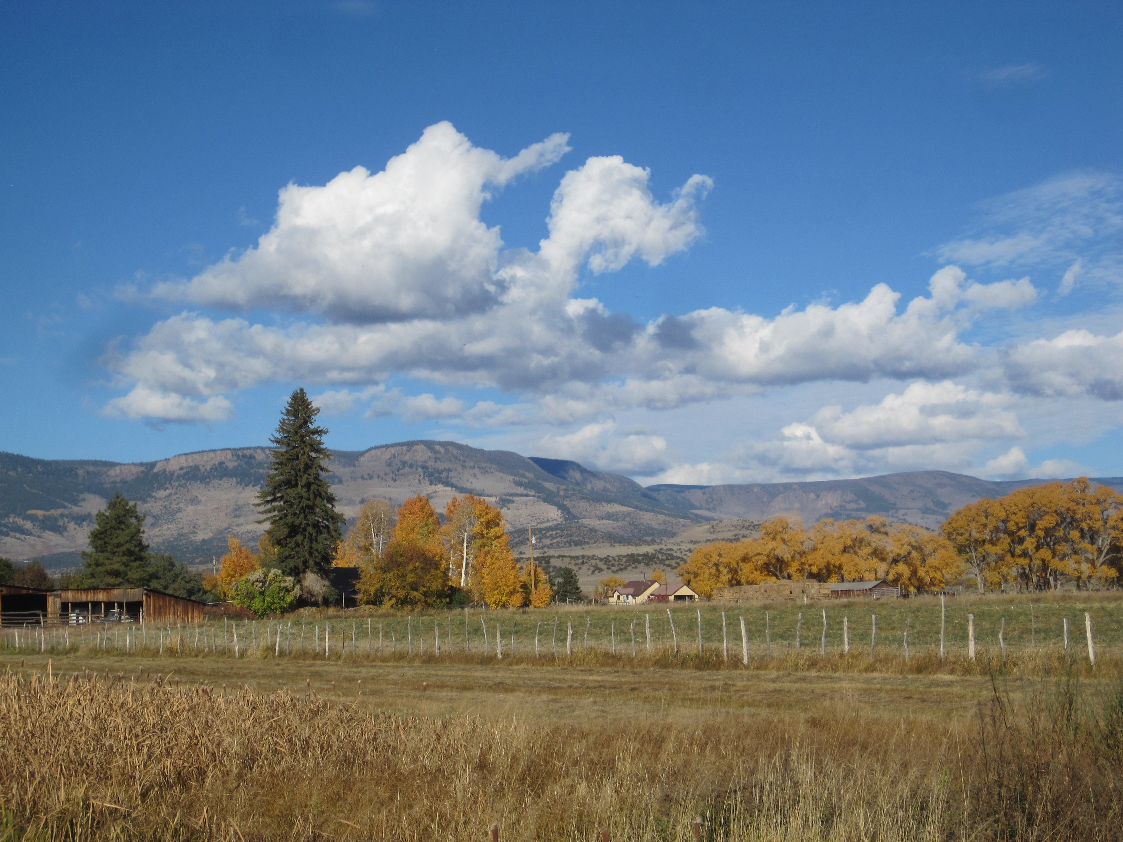
Looking North to the home ranch and the foothills of the La Garita mountains.
As the story unfolds to us……. a probably restless, no doubt handsome and a most certainly hardy Duncan Colville moved to live within the shadows of the San Juan Mountains leaving behind his family plumbing business in Dumbarton, Scotland. And why Del Norte, you ask? Ha!! Strong women, of course. Duncan’s two sisters, Margaret and Robina, had made the jump across the pond before him deeply digging out a new life by the time of his arrival. Being a talented plumber, Duncan quickly acquired work in town, but it wasn’t long before he struck said land deal and commenced to give farming a go. A seemingly short lived career, it wasn’t long before farmer Duncan threw in the shovel and the bachelor life he was said to be tired of. He sold the ranch and with Scotland looking a far cry better, plans were soon made to return to the rainy hinterland of his family. Plans are sometimes made to be broken as before long he met a certain someone who changed history. Bitten by the love bug, no doubt…. farming suddenly didn’t seem so bad, the winters probably not so cold and the work maybe not so hard. Her name was Susan Knowlton and it was she who put a halt to Duncan’s “get outta dodge” plan. They married, bought another ranch and the rest is the remarkable story of a spirited family we have come to know and love today…. the Colville’s.
Suzanne and Duncan had two children who had four children and from there I simply lose count. What we do know is that the ranch is currently being run by Davie and Nemonie Colville, 4th generation ranchers and it’s one busy place!! Over the years the families have bought up neighboring ranches, built a whole lotta houses, raised a whole bunch of cows, had a gaggle of children and today it’s more liken to a small village. The Colville’s have opened their arms to spouses and friends with different backgrounds, beliefs, attitudes and ideas folding it all together with some serious magic. There is a solid love of the land and the animals and a deep passion of adventure, of travel and of life. It’s a very cool village.
4th and 5th generations…., Davie Colville and his beautiful daughter, Syana…. back in the day. Syana is now 13. photo taken by Topher DonahueDavie and his ranch hand, Martine standing atop of some certified, organic hay.Looking west towards the ranch which has grown considerably in both size and population since the days of Duncan and Suzanne.
And why are we telling you this story? Well, it’s because of Duncan Colville and a long line of big old hearts who have given us the sweet opportunity to live on this ranch in the most beautiful place we have ever had the opportunity to live. We feel to have been greatly gifted.
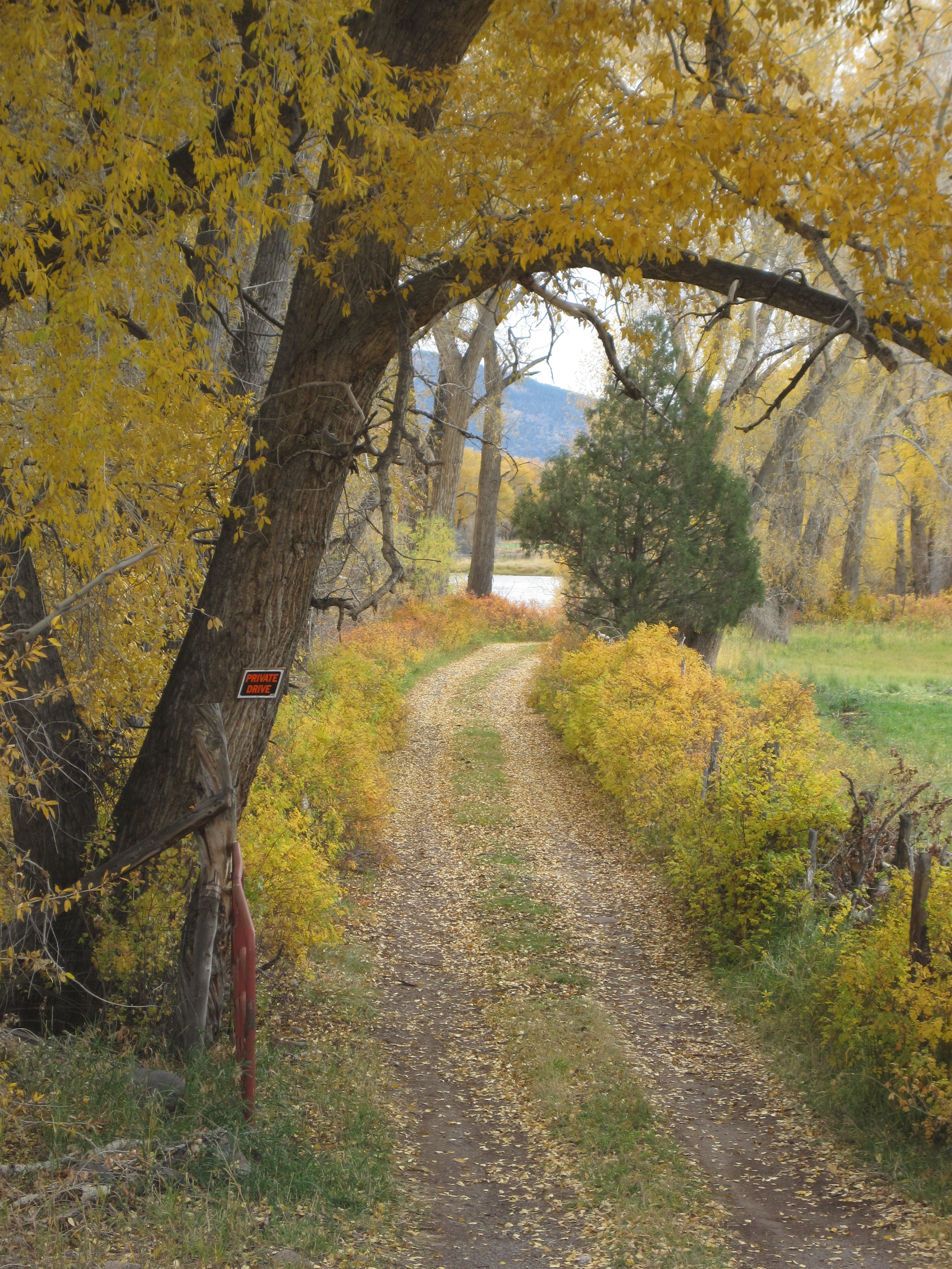
Crossing the Rio Grande – our cabin is on the right hidden in the cottonwood treesThis is the path that leads to our cabin. Prettiest darn driveway in these here parts.This is this view from our outhouse. That’s Del Norte Peak in the background with a dusting of early season snow.Looking towards the cabin.A view of the cabin looking East.Our front door. Come visit!! We have a large sleeping loft awaiting you!!And one of the best darn campfire gathering places this end of the valley..
And us? You’re probably wondering if we even have a home of our own. We really do, we actually have a few of them, but we’re much preferring to rent them out and live in this cabin on the river… which is far, far more suiting to who we are.
Our house in town is FOR SALE!!!! It’s a brand new house inside 130 year old walls. Want it? Lets talk!A shot of the town of Del Norte looking Northwest. We now live at the foot of those mountains in the background.
And the bike riding…. ? Oh, yeah, right. In trying to find the words to describe the riding at this end of the valley I’ve found myself following a mental thread that has lead me to realize that a fundamental shift has occurred in both of our riding philosophies. Sure…. flowy, sweet, single track is undeniably fun and a trail with the hard to find perfect rhythm is simply hard to beat, but it’s by no means what we seek out these days. Perhaps it’s the almost 7000 miles of touring, bikepacking and day rides we’ve laid down over the past year and a half, perhaps it’s the thousands of the hours in the saddle that has bore a new neural groove. For whatever reason we have come to know that the mountain bike riding right here, right where we are, is exactly what feeds our spirit. Sure, we have some sweet single track in Del Norte and yeah, we’re slowly getting some world class trails, but what we really seek has been here since the days of Duncan Colville. It’s the hundreds of miles of two track roads that give us the space to explore daily new turns with not a soul in sight, just us, out solo on a journey that lets the mind expand. It’s the exploring and the steady, rythmic breathing that is central to life here as we know it. Who would have thought that with all our travels we’ve come back home to find that for who we are, perhaps for whom we’ve become, what we desire the most is right out our front door. Go figure. I do think it’s what books are made of.
A typical two track surface in the La Garita Mountains.Rides with views like this of the Sangre de Cristo Mountains.Desert plants, crazy rock formations and mountains.The path that leads from the main ranch to our cabin on the river with the San Juan Mountains in the background.
At the end of the day we thank Duncan and whole Colville clan for gifting us a part of their beautiful space here on the banks of the Rio Grande. Have we given up traveling…. ? Gary is content staying put for the moment and me, well, content as I am I have a bit more of the travel bug. I’m gunning to ride the length of Baja this winter when the river is frozen and the Siberian weather sets in hard. But, for now, what’s to complain about?
Spring is a slippery, elusive concept here in the San Luis Valley with this year being no exception. Some days are warm with temps in the 50’s, even 60’s and we’re darn proud of our sunshine, a commodity of regular dependability . The spring winds…. not so proud. They rage with such force and fury as if we’re paying penance for some ancient, unforgivable sin with afternoon gusts up to 40, sometimes 50 MPH. With that said, if one is to get out at all it must be done early as the winds kick up around noon. That’s what happens here in the San Luis Valley and it can kinda suck the Pollyanna right out of a person. If not careful “it” (the wind) can mess you up and stir up an anger that feels old and deep and powerful. Whata we do…???… we just put our heads down and think about something else.
Life in the cabin, on the ranch, has worked itself into a comfortable rhythm. We wake up, drink coffee, space out in front of the computer, eat breakfast, download podcasts, button up, zip up, plug in, click in, step outside and ride. Given the 24/7 togetherness we’ve come to know this year our morning rides have become a cherished solo time for both of us to do with exactly what we want. For me a ride begins with the podcast of choice which recently, is always…. “Snap Judgement” to which I’m seriously addicted. I’m addicted in some old and deep way that feels as strong as the wind in spring. Before I’m even off the ranch I’m feeling “it” the beat of this smoking hot, NPR podcast that brings stories about life, to life…. with a beat. I’m in love with Glynn Washington, the host – he’s the smokin’ hot part. It’s his story telling “beat” that sets the tone and I’m hooked and by the time the story unfolds I’m in hard. Now why a white girl with a European heritage as old as mud can hook so deeply into just about any “brother’s beat” is a mystery, but I do. Perhaps the answer hasn’t found it’s expression yet and is just spiraling around somewhere in my DNA…..whatever. I put my head down and get sucked into the story. I’m a “Snapper”.
I turn onto the frontage road and head East for a short time before turning South into our playground which is miles upon miles of public land with a combination of dirt roads and trails, volcanic plugs, mountains, rocks and rocks and very cool rocks and a freedom that goes, literally, all the way to Mexico.
Heading South on one of many roads which wander around in the Limekiln area just East of Del Norte.Rocks and rocks and rocks some of them perfect for climbing.
To the locals the system of areas out here are often called The Stone Quarry, Limekiln, Mulhauser and/or Rifle Range. I don’t know what the non locals call it perhaps because there are so few of them. This land provides a time and a place to be completely alone with only, perhaps, a mountain lion keeping a watchful eye.
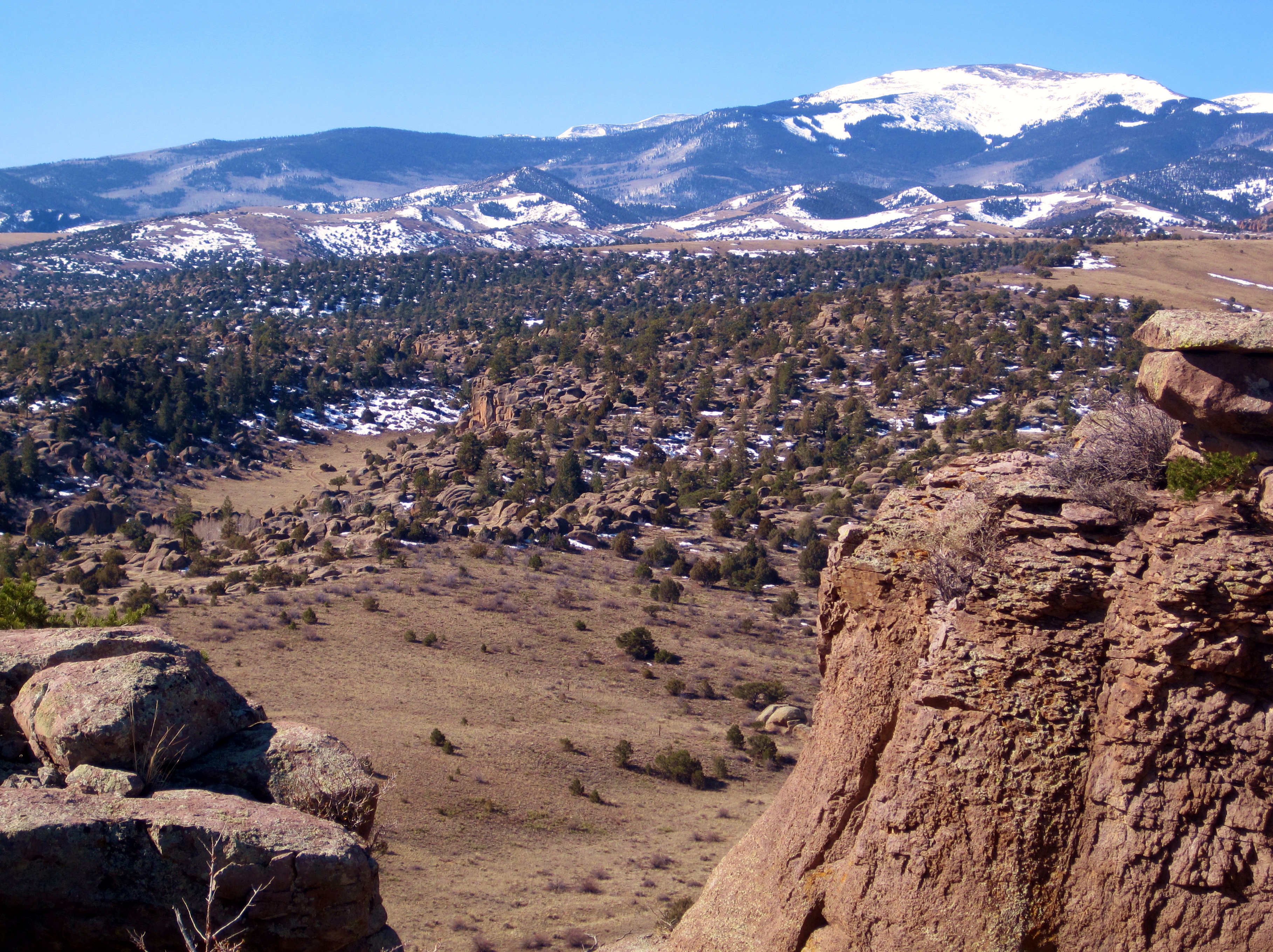
Looking South from a ridge line into the South San Juan Wilderness..
At some point during these morning rides it starts to happen…..the beat, the story, the steady, deep breathing all lay the foundation as the world unfolds and folds back into itself and a predictable sense starts to surface. Stronger than the wind it’s a swelling in my chest with a deep, deep, deep appreciation for the good health and extremely good fortune to be simply a part of this very moment. I put my head down and think …. about this richness.
Looking North/Northeast towards the Sangre de Cristo Range working the way back home.
Sometime later, so lost in the stories and the land, I turn back and start picking my way back home. As I turn West, generally sometime before noon, the winds, which are always a headwind, have picked up making it hard hold to and hear the stories. I put my head down and sit tight with the little piece of solo morning magic I’ve just experienced and look forward to tomorrow.
The above post was written almost a week ago….. try to guess where we are now 🙂
I’ve been wanting to do some gear and equipment posts. But first, I’d like to share what we see out in our yard each morning, all 200 or so, acres of it.
This is at daybreak this AM. We had a dusting of snow last night. Too bad they can’t stay cute like this…
We have over 100 baby calves, so far. It’s been a really easy year for them, weather wise.
OK, on to the bike geeky stuff…
I just built up a Shimano Alfine 8 speed Internal Gear Hub (IGH) for my bike. I’ve been pondering doing this for some time. I came really close to buying one before our big trip but in the end decided to go with what I knew. After returning home the itch started again.
The wheel is way strong. I had the opportunity to get one of the last Stan’s Flow (now Flow EX) rims in 36 hole for a song. I ordered a 36 hole hub to go with it and picked up some DT Competiton (14/15) spokes and brass nipples. All spokes are 269mm, no need for different length spokes. It’s recommended to build up IGH hubs 2 cross. It built up really nicely. I know I could have built it lighter but this is an experiment and cost is a factor.
As much as I love riding singlespeed, or dinglespeed, it’s a bit limiting on the flatter sections of our rides. As we travel, having a few gears seems to be worth it to me, these days. The Alfine with 32/20 gearing is supposed to be the equivalent of a 12-38 cassette. I’m using the Alfine trigger shifter. It works great but the shifting is backwards from a normal drive train. Shifting is immediate; no lag. The down shift doesn’t happen until you let off of the shifter to release the ratchet though.
Wait, weight! Yikes! What happened to my nice, light bike? It’s over 3 1/2 lbs. heavier than it was in dinglespeed trim. Part of the added weight is the heavier rim, 4 more (and heavier) spokes, brass nipples and fresh Stans in the tire when I changed it over. Still… darn! Supposedly the Alfine IGH is no heavier than a mid range (cost) mountain triple, if you add in all the bits and pieces.
I’ve got around 15-18 hours on it so far. I like it. I do wonder how efficient it will be. IGH is supposed to be a bit less efficient than a conventional derailleur set up. At least under ideal conditions…
This it where the IGH blows a conventional drive train away. I always try to avoid riding in these conditions but it does happen, especially on a multi-day trip. On longer trips, expect it. Notice that the chain has almost no mud on it. A derailleur set up would have already been clogged up, the tire probably wouldn’t turn and the rear derailleur would be at risk of being torn off. In these conditions, and hopefully in a bit less harsh conditions, the IGH will be more efficient.
This hub was designed for a commuter bike. As such Shimano didn’t spend time or money in an effort to save weight. The Alfine 8 has a reputation as being up to the task of mountain biking even though it wasn’t intended for that purpose. The newer and more expensive Alfine 11 speed hub, apparently, isn’t up to the task.
The photos show zip ties for cable routing. I now have stick-on cable guides on the downtube but I stayed with zip ties on the chainstays. I have the option to run the shift cable down the seatstay but I think I prefer this.
It shifts lickety split- always. Adjustment is dead simple. Removing the wheel is relatively painless. It’s pretty much silent and it was inexpensive too. I’ll try to give an up date in a few months. There are those of you who think I’ll be on a Rohloff soon. 🙂 Not very soon, anyway.
On January 27th, close to 3 weeks after arriving in Terlingua, Texas the forecast was looking dim … cold and windy which was an unusual event coming from the land of eternal good weather. We took that as our exit sign, packed up and headed down the road to Southern Arizona in search of sunshine and warmth…. just like lizards.
Our first night out was spent at a Loves truck stop in Van Horn, West Texas, only to wake up the next morning to 15 degree temps. Not a good start. Not at all. The second night was spent camping just West of Columbus, New Mexico, a few miles North of the Mexican border. Sure, it was still cold, but things were looking up….. kinda. Little did we know that we would spend about a week in all, hit or miss, in less than desirable temps and conditions and let it be known, we had little tolerance for it.
Camping just North of the Mexican-New Mexican border near Columbus, New Mexico
We spent a couple of cold and windy days exploring the Eastern side of Chirichauas, a place which deserved far more attention from us than it received. Next time.
In the meantime we endured. As we drove deeper into Southern Arizona we wondered why, so often, it feels like the forgotten child to us. It’s so far away, so different from our usual haunts, yet we are stunned and awed every time with its brilliance. We wonder how and why Southern Arizona ends up on the back burner only to be acknowledged when things get tough…. and cold. We’re sorry.
Fields of tall, golden grasses.Looking North from the hills outside of Patagonia, AZ
We reached Patagonia, Arizona a stunningly beautiful place with tall, tall grasses and long, rich, textured vistas, layers upon layers of them. We also entered the Sonoran desert, a world unto its own and a close cousin to the Chihuahuan desert of which we had just left. It’s differentiated, in part, by elevation, the Sonoran being lower and warmer than the Chihuahuan, and by the vegetation which lower elevations can host.
Still cold and getting colder we lizards were contemplating hibernation, but we forged on, in hope. We traveled 30 miles North of Patagonia to camp 2 nights at the base of Mount Wrightson outside of Sonoita, about 80 miles South of Tucson… it’s a part of the SW where the oak tees, Arizona sycamore and manzanita live. These trees resound with us on some deep, old, strong, steady, sturdy level. Maybe there are past lives. Maybe we were oak trees. Both of us.
We start hop scotching our way North along the Arizona Trail (AZT) following these signs.We set out for a ride along the AZT, North to South, at the base of Mount Wrightson.Next day, skies are clearing off, riding along the AZT South to North, same area.Looking West towards Mount WrightsonA section of the AZT just south of Tucson..And every single night provided stunning sunsets.
In all, we spent 4 days south of Tucson exploring the Arizona Trail (AZT) which, as many of you know, is an A #1 desert trail system, all 750 miles of it that runs through Arizona, from the Utah to the Mexican border. It’s flat out awesome. We continued our journey North to Tucson, following the AZT as closely as possible. It was still cold, but an end was sight as the forecast was looking up. We camped at Colossal Cave, close to Tucson which is actually on the forever elusive border separating the Chihuahuan and Sonoran deserts….. then all hell broke loose….. we were in a cactus jungle. Really, it’s quite stunning as many of you already know. And its 75 degrees. Bingo!!!
The Saguaro, the Granddaddy of them all.On the 50 Year Trail outside of Catalina State Park, Tucson
Tucson…….. it’s a city surrounded by beauty. To the East and the West close to the city are The Saguaro National Parks and not many cities can say they are that close to National Parks. To the North and the East is the Catalina National Forest with peaks up to 10,000 feet and to the West and South are layers upon layers of mountain ranges which fade into the distance and are simply too numerous to name. Within the city are various cactus jungle open spaces as well as trail systems and around the perimeter of the city are the foothills which are crammed solid with cactus and a few, sweet trail systems. The textures are simply amazing. And did we mention that it was 85 degrees??? Yuppers.
While in the Sonoran desert we turned into pseudo, wikibotonists and developed relationships with the cactus and plants. We bought a book on cactus and read through all the info that the parks gave out and played the “name that cactus” game which passed the time.
The misleadingly named cactus, the teddy bear cholla . Photo by Amy Carr
While in Texas we thought we had met the meanest kid on the block, the cats claw. Rightly named you can easily slide over its smooth, backward facing thorns only to get raked, nailed, big time on the retrieval. But, in the Sonoran desert, we met the teddy bear cholla who won the “Obscenity Recipient Award”. It’s a jointed cactus that willingly releases sections of itself onto any poor sucker who even looks at it wrong. It does this by inserting it’s bad ass barbed thorns one would swear had been dipped in poison. It hurts big bad!! Many of you know what I’m talking about here don’t you??? You’ve called it naughty names before, haven’t you??? See???
Jumping Cholla on the left, saguaro on the right
Above, on the left is a jumping cholla, a close second cousin to the teddy bear cholla in both technique and effect. With this big fella at least the name gives you a slight heads up, but I think overall, it pales in evilness to the teddy bear.
Professor Gary giving a cactus survival lecturePatti studying. photo by Amy Carr
While in Tucson our dear friends Dallas and Amy from Albuquerque came down to play with us. As always, we love to meet up with friends. Hint, hint.
Amy and Dallas from Albuquerque, New Mexico
Amy went to college in Tucson and liked it so she stayed 10 years so she was equipped to school us well. We spent Valentine’s Day with them and went on a hike where Dallas, impressively, came in rather handy.
The impressive Dallas Broad. photo by Amy Carr
And we watched the full moon rise.
Photo by Amy Carr
We were so sad to see them leave.
With their departure setting the tone we started working our way back North, camping, riding and hiking here and there, through Silver City, through Albuquerque to see friends and family, then home, to our lovely little cabin, sunny 50 degree temps and lots of baby calves playing in our front yard. Cute 🙂 See, it all works out in the end.
Sunset looking West over Tucson.
Southern Arizona,……. we promise that the gifts you gave will not be forgotten. Like lizards., we’ll be back. Next year.
Next stop…. we leave mid March for the Pacific Northwest to visit both of our families, friends and a new grand baby boy. Yeah!!
I’m not particularly proud of it, but at the beginning of every trip, such as what we’re on, I go through a period of internal chaos with the predominant characteristic being that of losing things and spending an inordinate amount of time looking for things. It’s a pattern. Sad to say. Darn it.
We left home over a month ago with our pick-up, our little trailer, 2 bikes and a relatively small amount of stuff for a trip of this length. That said, the degree in which I have lost (which is unusual) or misplaced (the usual) my stuff…. just saying… has been OVER THE TOP!!! In the first week alone I Iost, not misplaced, a favorite sweater on a short hike in Terlingua. Gone. I left my Rx sunglasses at a pizza place, but they were returned to me the next day. Fetching angels at work once again. Natch. And I left our camera on the counter of the Big Bend Visitors Center for which we had to drive an extra 25 miles there and back to get. Double natch. These and numerous daily misplacements of normal, everyday things was driving me, not so quietly, nuts.
In an uncommon, but highly productive move I asked Gary for advice on how to overcome this as by now, it’s obvious, I have a problem. Instead of being defensive and in denial which has been my usual MO, I asked him to watch me and give advice. Risky move on my part…. could have opened the proverbial can of worms. Not so. Gary simply said, “put everything back where it belongs”. BINGO!!!! Dah. It works.
It’s been a little like a 12 step program…. First you admit that you have a problem, right? …. then ask for help from someone you trust. Really? It’s taken me this long? Sunglasses go back in the the case, not on any convenient surface at hand. Wallet goes into the glove compartment, not in some nameless bag in the back of the pick-up. Toothbrush, back in the travel bag which goes back in the closet, not in a pocket. It’s for things such as these that brings me to the real reason for which I’m outing myself and my “problem” to the blogging world …..
…….. It’s to say thank you to a very important person in my life. Sri Gary.
After 23 years of being with someone you’d think there’s not much left to learn, not so sahib. I’ve been watching Gary closely lately, trying to emulate his highly organized and efficient ways and have come to truly appreciate him in a new light. Gary has a built-in, state of the art Zen unit, straight from the factory, no rebuilt unit here. He is present at all times. He knows where everything is. His movements are gentle and slow and he never forces or breaks anything. He gives thought as to how and why things work…. no guessing game. When he’s putting a spoon back in the drawer, he’s actually one with it… no doing things on automatic. He talks when he has something to say. He is quietly, happily, centered. He is organized. Go figure.
So on this day (OK , so it’s Valentine’s Day), for these traits, for this man, I give thanks….
Itching to get back to the National Park, Gary and I head out the following day to see what we can dig up in the area of the park serviced by the Rio Grande Visitors Center, needless to say, it’s along the Rio Grande. Us on the North and Mexico on the South… so close, but ahahah…. don’t touch. That’s a no no!!!
We found 2 hot springs. The first was an off the map springs made from piling up a bunch of rocks at the rivers edge 1 mile down the trail from our campsite. Nice enough.
The second one was awaiting us at the end of a lovely 2.8 mile trail. This one was a tad more civilized and built up, on the map, quiet, clean, perfect. No typical sulfur odor either.
This kayaker just floated by..
We did a 47 mile bike ride on the dirt roads which encircled Tully Mountain.
We didn’t see a soul the whole time and we were a smidgen too late to see these folks.
And we did a few canyon hikes
Gary…
The most striking thing to me about being next to the Rio Grande in the Big Bend area is grasping that our little cabin sits not 200 yards from the very same river, only about 700 miles upstream. It’s a very different perspective…
Many would describe the area as “desolate”, and it is in it’s own way. Many also might avoid it because Texas is virtually all private land, true too. But, between the National Park and the State Park there’s a whole bunch of amazing, warm, incredibly quiet, litter free, cattle free, virtually people free land to play in. The National Park has hiking trails and jeep roads, plenty of both. The State Park has some hiking trails too, plenty of jeep roads, and a first rate trail system. In it is an IMBA Epic loop of around 60 miles. I’d rate the trail system an 8 out of 10. It’s hard to do much better than that.
Right next door to the State Park trails is the Lajitas Trail system, these are mostly fast and flowy trails that pretty much anyone can enjoy.
Then there’s some unrecognized trails that pass through private land, no one seems to mind though. I won’t share details on those trails here. I think I did get the chance to ride, pretty much, all of the area trails at least once.
I was Itching to do a little bikepacking, Reilly and Kimberly were too and they were my (perfect!) tour guides. They are both accomplished and talented riders, well versed in bikepacking and they know these trails extremely well. I also really like them both! We rode the ‘Epic Loop’ beginning and ending in Terlingua using trails almost exclusively. They know the unofficial trails that allow this connection. Thanks for the ride(s) you two!
Patti… back at cha….
Before I forget…. I want to give a big thank you to Kimberly… One morning she and I took off to the National Park and did the South Rim Trail which is a 15 mile loop that leaves from the Chisos Visitor Center and goes up up up, loops around the rim and comes back down. Most of all I’m grateful for the close to 8 hours of chatting that went on between us, almost none stop…. Aauugghhhh… I was in serious, serious need of a jabberwalk fix!!!! Thanks!!!!
The beautiful and talented Kimberly…
Overlooking Emory peak…
Mixture of flora up high…
In all we were in this area 2 days short of 3 weeks so we got in a lot of hikes, rides and local stuff like the farmer’s markets, art shows, hanging at the bike shop, Desert Sports**** … You know, stuff.
Terlingua, Reilly, Kimberly, Alex and all the good folks in the hood… We Thank you for sharing your wide, open, space.
Gary again…
One of the things about the Terlingua area that is special are the people. There’s a core group of folks that are passionate about the land- boaters, guides, hikers, mountain bikers, park employees, bike shop folks, etc. I won’t name them all. Many of these folks could be great friends, we share the same passions and values. It’s somewhat refreshing to see ‘our kind of folks’ living the life they choose down there, living simply, active and content.
Cycling adventurist, bikepacker, travel writer, photographer, speaker, professor of philosophy. Route designer of Ted King's VTXL, the Green Mountain Gravel Growler beer tour, the Silk Road Mountain Race course 1st edition, and many more.